
This campground is usually open Memorial Day weekend through Labor Day weekend with full service and, depending on snow conditions, is usually open through the middle of October with reduced service.
Available activities include hiking, fishing, bicycling, motorcycle, and ATV. Fishing in Ophir Creek. A short drive will take you to various trailheads.
Coaldale Campground is located on the banks of Hayden Creek and is a quiet campground with only 10 campsites. Most of the campsites are walk-in sites with small parking areas. Water is available at Hayden Creek Campground. The area is thick with gamble oak, juniper, and cottonwood trees . Sites 1-5 are walk-in sites for tent camping. Vault toilet is available only during peak season
Davenport Campground was one of the first Forest Service campgrounds, and is near the now-abandoned Squirrel Creek Campground, the very first Forest Service campground in the country. In 2010, Davenport was rebuilt to evoke the original 1920s design. Adirondack shelters and a common cooking shelter with stone fireplaces were built and old-style log picnic tables add to the historic character of this campground.
The campground offers access to an array of hiking, mountain biking, motorcycle and off-road vehicle trails.
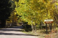
The campground sits in a grassy meadow surrounded by aspen and spruce trees at an elevation of 8,500 feet. Squirrel Creek runs alongside this scenic facility in the Wet Mountains of southern Colorado.
The Timberline Campground, near Kenosha Pass, is about 7 miles southwest of the small town of Grant. The abundance of aspens at the site creates impressive fall scenery along the forested hillside. Wildlife in the area includes golden eagles, elk, mule deer, moose, chipmunks and porcupines.
The family campsites are divided into two loops, that are separated by a rise. Both loops sit among a stand of aspen, spruce and lodgepole pines along Hoosier Creek. The campground sits at an altitude of 9,700 feet and features mild summer temperatures and cool nights.
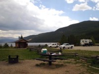
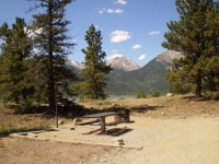
Lakeview Campground, with wonderful views of the Twin Lakes Reservoir, offers a large space with options for tent, RV and group camping. Located about 29 miles north of Buena Vista, Colorado, the campground attracts plenty of hikers looking to explore nearby nature and backpacking trails in the Mount Massive Wilderness. Boating and fishing enthusiasts spend their days at the Twin Lakes Reservoir and Mt. Elbert Forebay.
Lakeview is situated in a ponderosa pine and sage habitat at an elevation of 9,500 feet. The site is between Mt. Elbert Forebay and Twin Lakes. The Twin Lakes Reservoir spans 2,805 acres and Mount Elbert stands tall at 14,433 feet.
Nearby is the Mount Massive Wilderness area, 30,540 acres encompassing Mount Massive, Colorado’s second highest peak at 14,421 feet. Much of the wilderness is above timberline with many alpine plant communities and permanent snowfields.
This campground is the highest elevation campground on the Salida Ranger District. The elevation is 11,000 feet and the campsites are situated on the north shore of the North Fork Reservoir. The campground is small with only 9 sites. The road to the campground is very rough and not recommended for vehicles towing trailers. High clearance vehicles are a requirement for reaching this campground.
Reservations are not taken for this campground.
Twin Peaks is a first-come, first-served campground located west of Twin Lakes Reservoir in a shaded aspen and lodgepole pine forest. It is located above the whitewater of Lake Creek at 9,600 feet with spectacular views of the Sawatch Range. The Continental Divide and Mount Elbert trails are in the nearby area.
High altitude sickness may occur at this altitude.
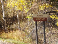
Spruce Group Campground, located in the Lake Isabel Recreation Area, is a great place to bring groups for picnicking and camping on the scenic Lake Isabel. The campground accommodates 50 guests for day-use and 40 guests for overnight camping. Some RVs can fit in the paved parking area for added convenience.
Lake Isabel is one of the few lakes in Colorado developed purely for recreation purposes. Built by the Civilian Conservation Corps, the lake attracts campers who enjoy hiking, canoeing, fishing and watching for wildlife. St. Charles Creek flows near the campground and offers additional opportunities for fishing.
The St. Charles Creek runs next to the campground, and dense spruce trees surround the site. The shoreline of Lake Isabel meets the rocky slopes of the Wet Mountains at an elevation of 8,600 feet.
The Pike and San Isabel National Forest includes over a million acres of wilderness and over half of Colorado’s mountain peaks that reach above 14,000 feet.
May Queen Campground is located at the far western end of Turquoise Lake in a shaded lodgepole pine forest. Conveniently perched near the Charles Boustead Memorial Tunnel, May Queen offers easy access to boating, fishing and hiking.
Incredible views of the Holy Cross and Mount Massive Wildernesses can be seen from the area, and visitors are likely to see native wildlife like chipmunks, beavers and porcupines.
The Charles Boustead Memorial Tunnel is a 5.5-mile tunnel that transports water from the Fryingpan and Roaring Fork River Basins through the Continental Divide to the Arkansas River Basin by emptying water into Turquoise Lake.
The campground sits at an elevation of 9,900 ft. on Turquoise Lake. Most campsites are situated on a level, open field along a creek, feeding into the lake. Six first come-first, serve-sites are perched on the wooded hillside above the creek.
Nearby is the Mount Massive Wilderness area, a 30,540 acre expanse encompassing Mount Massive, Colorado’s second highest peak at 14,421 feet. Much of the wilderness is above timberline with many alpine plant communities and permanent snowfields.
Developed campground camping with the following activities: Access to non-wilderness in the Sangre De Christo mountain range from the Rainbow trail. The Rainbow trail is a motorized trail which includes ATV and motorcycle use and runs along the foot of the Sangres. Wilderness trails, that climb above the Rainbow trail into the Sangres, are only accessed by foot or livestock. The closest wilderness trails include North Brush and South Brush. High Mountain lakes are accessible from the wilderness trails. Forest Service Road 198 is accessed from the Campground and will take you up to non-wilderness areas in the Sangres. Please check a map for other recreational opportunities close by the area.
Devil’s Head Campground resides at the base of Devil’s Head Fire Lookout Tower and Devil’s Head Trail #611. Rock formations dot the landscape and provide outstanding views of the surrounding area. No dump station, electricity or water hook-ups available.
Peak season is 05/22-09/08 and extended season runs through 09/09-09/21. During peak season, the campground offers full service. Extended season has reduced services such as vault toilets, water, trash, or a host may not be available.
This campground appears on the following maps:
- Pike National Forest
- USGS Quad Devil’s Head
- National Geographic Trails Illustrated #135 (Deckers / Rampart Range)
Springer Gulch Campground is located in the Eleven Mile Canyon, a short walk from the South Platte River, offering sweeping mountain views at an altitude of 8,300 feet. Fly fishermen will find an abundance of trout and visitors enjoy exploring area trails.
Located on the eastern shore of Turquoise Lake, Matchless Campground has 20 sites and can accommodate larger recreational vehicles. Facilities include restrooms, potable water, picnic tables, and fire rings. This campground is adjacent to the boat ramp and parking areas. Firewood is available at the host site. During weekdays, usage is moderate, but heavy on weekends.
Collegiate Peaks Campground is located 11 miles west of Buena Vista, Colorado, along Middle Cottonwood Creek near the top of Cottonwood Pass. The campground offers well-spaced campsites and scenic views of the surrounding mountains. Visitors enjoy fishing and exploring local trails.
The campground sits at an elevation of 9,800 feet, tucked in a dense stand of ponderosa pine and aspen. Some sites sit alongside the creek while others are tucked back in the woods. Afternoon thunderstorms are common during summer months.
Cottonwood Pass is a high mountain pass across the Continental Divide in the Sawatch Range of the Rocky Mountains. The road reaches the divide at an elevation of 12,126 feet.

Aspen Campground is an excellent place for campers looking to relax, hike, fish and enjoy the sounds of nature. The campground sits near Jefferson Creek, a few miles downriver of Jefferson Lake. The lake is one of the highest elevation lakes around, capping 10,685 feet elevation and bordered by steep 12,000 foot peaks Fishing in both the creek and lake offer promising catches of trout. Another noteworthy aspect of the campground is its access to the Colorado Trail.
Located off the Halfmoon Road (FSR 110), Halfmoon East is a first-come, first-served campground near the Mount Elbert and Mount Massive Trailheads at 9,000 feet. This is a very popular campground for hikers. Facilities include picnic tables, fire rings with grates, and vault toilets. There is no potable water available at this campground, but water can be obtained up the road at Halfmoon West Campground.
High altitude sickness may occur at this altitude.
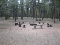
Ponderosa Group Campground, located near the sparkling 40-acre Lake Isabel, beckons large groups for picnicking and camping in the Lake Isabel Recreation Area.
The campground accommodates 61-120 guests for day-use ($150 day use fee) and 60 guests for overnight camping. Visitors can enjoy entertainment like volleyball and horseshoes, or head to the lake for canoeing and fishing.
Lake Isabel is one of the few lakes in Colorado developed solely for recreational purposes. Built by the Civilian Conservation Corps, the lake attracts many campers who come to hike, canoe, fish and spend time bird watching. St. Charles Creek flows near the campground and offers additional fishing opportunities.
Shady pine and aspen trees are scattered throughout the campground. The shoreline of Lake Isabel meets the rocky base of sweeping mountains at an elevation of 8,600 feet. At 8,600 feet the area enjoys cool summer days, a welcome relief from the heat in the plains far below.
The Pike and San Isabel National Forest includes over a million acres of wilderness and over half of Colorado’s mountain peaks that reach above 14,000 feet.
Lodgepole Campground is a creekside destination with incredible Colorado mountain views. The campground is located 3 miles south of Jefferson Lake, one of the highest elevation lakes around, capping 10,685 feet elevation and bordered by steep 12,000 foot peaks. Fishing in both the creek and lake offer promising catches of trout. Another noteworthy aspect of the campground is its access to the Colorado Trail.
Sunnyside Fishing Site is located on the northeastern shore of Twin Lakes Reservoir.
Spillway Campground is perched along the South Platte River near the base of the dam of Eleven Mile Reservoir. Adventurists and families alike will find things to do here. Birding is excellent, as is hiking. Rock climbers enjoy the solid rocky cliffs of the canyon and fly fishermen find abundant catches in the river.
Printer Boy Group Campground is located near Turquoise Lake, in an area with plenty of recreational opportunities, including boating, fishing and hiking.
The campground is situated within walking distance of the lake shore in a forest of lodgepole pine and sub-alpine fir.
The Mount Massive Wilderness area, a 30,540 acre stretch of primitive land is nearby. Much of the wilderness is above timberline with many alpine plant communities and permanent snowfields.
South Meadows campground, located 5 miles north of Woodland Park, provides a scenic spot for campers to rest and enjoy the many recreational offerings of the area. The campground attracts avid hikers and bikers with access to the multipurpose Centennial Trail, as well as visitors looking for a central location for day trips to Pikes Peak and the Garden of the Gods.
Garden of the Gods is a National Natural Landmark in Colorado Springs, featuring incredible rock formations, impressive vistas and a free visitor and nature center.
Campsites are tucked in a stand of ponderosa pines at an elevation of 8,000 feet. To the east is Mount Deception and to the north is the 5-acre Manitou Lake. Afternoon thunderstorms are common in summer months and temperatures are generally mild, with warm and pleasant days and cooler nights.
This campground is located 1.7 miles east of Woodland Park on Rampart Range Road, FDR #300. This campground has 13 sites.
This is a standard, non-electric campground. Firewood, shelter, and water are not provided.
Cascade Campground is located in beautiful Chalk Creek Canyon in central Colorado. This popular facility sits near Cascade Falls and within 10 miles of a private hot springs resort, making it an ideal location for rest and relaxation. It’s also a great destination for visitors looking for off-road vehicle trails.
The campground is situated in a dense forest of Douglas fir and aspen at an elevation of 9,000 feet in Chalk Creek Canyon, which gets its name from the soft, white, chalk-like kaolinite canyon walls. Kaolinite is a clay mineral that was deposited by percolating hot springs.
Chalk Creek is just across the road from the campground. It flows 27 miles eastward from the Collegiate Peaks before joining the Arkansas River. Chalk Lake is a mile east of the campground.
This location is available on a first-come, first-served basis only. Visitors are required to physically arrive at the campground to purchase and claim a site. Once on-site, you may be able to pay for your campsite(s) by scanning a QR code using the Recreation.gov mobile app, and the Scan and Pay feature.
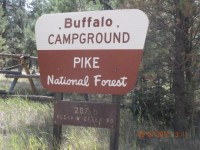
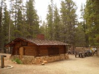
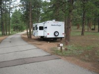
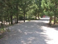
Buffalo Campground is one of two facilities within the Buffalo Creek Recreation Area, about an hour’s drive southwest of Denver, Colorado. Visitors enjoy a variety of recreational opportunities, including hiking, mountain biking and trout fishing.
The campground is situated near Buffalo Creek at an elevation of 7,400 feet in the Front Range of the Rocky Mountains. Summer temperatures are mild and range from 75-80 degrees during the day to 55-65 degrees at night.
Picturesque White Star Campground lies at the foot of massive Mt. Elbert, among fragrant ponderosa pines. The campground provides convenient access to Twin Lakes Reservoir for plenty of water recreation opportunities.
It also works as a base camp for hikers and mountain bikers who love to explore nearby trails such the Continental Divide National Scenic Trail and the Mount Elbert Trail.
The campground, at an elevation of 9,200 feet, sits on the north side of the Twin Lakes Reservoir near the base of Mount Elbert.The Twin Lakes Reservoir spans 2,805 acres and Mount Elbert stands tall at 14,433 feet.
Nearby is the Mount Massive Wilderness area, a stretch of 30,540 acres that encompass Mount Massive, Colorado’s highest peak at 14,421 feet. Much of the wilderness is above timberline with many alpine plant communities and permanent snowfields.
Parry Peak Campground is a first-come, first-served campground located in a shady ponderosa pine forest along the whitewaters of Lake Creek. This campground is a favorite among anglers with a spectacular view of Parry Peak. Access to the Continental Divide Trail is just down the road.
High altitude sickness may occur at this altitude.
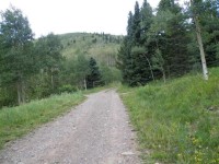
Bear Lake Campground is located in the Bear River area, 14 miles southwest of Yampa on Forest Development Road 900.
This campground is on the Flat Tops and is managed by the Yampa Ranger District.
The campground has a rustic nature with most of the 43 sites naturally screened from one another. It also boasts 4 double sites and 1 triple site to accommodate larger groups.
The campground has been a favorite of visitors for many years. It typically opens for Memorial Day and closes sometime in October, dependent on weather and use.
Sites are available on a first come, first served basis. This area accesses some great fishing and hiking.
Surrounded by the 235,000-acre Flat Tops Wilderness, the views are spectacular.
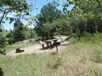
Buffalo Springs Campground sits on a rolling hillside in the San Isabel National Forest, providing an ideal setting for biking, hiking, horseback riding and rock climbing.
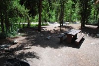
The beautiful Spruce Grove campground is positioned beside large rock outcroppings on Tarryall Creek. Magnificent hiking trails to the Lost Creek Wilderness Area are just steps away from the Creek Bridge. Located just 14 miles outside Lake George, Colorado, the area’s wild inhabitants include black bear, mule deer, elk, bighorn sheep and bobcats.
At an elevation of 9,813 feet, Geneva Park Campground offers cooler temperatures during the hottest of summer months. Along the Guanella Pass Scenic Byway, this campground is near prime spots for wildlife viewing, scenic driving, landscape photography, hiking, summiting 14,060 foot Mount Bierstadt, and access to 4-wheel drive roads. No dump station, electrical or water hook-ups available.
Red Rocks Group Campground is located 4 miles north of the town of Woodland Park, Colorado. Visitors enjoy the area for hiking, biking and visiting the nearby 5-acre Manitou Lake.
This rustic group site is situated in a ponderosa pine forest at an elevation of 8,200 feet. A nearby hiking trail leads to a unique red sandstone formation. Most of Red Rocks Group is shaded by sweetly scented ponderosa pine trees.
Campers looking for a pleasant fishing destination with great mountain views will enjoy camping at Jefferson Creek. The campground is located a short drive or hike from Jefferson Lake. The lake is one of the highest elevation lakes around, capping 10,685 feet elevation and bordered by steep 12,000 foot peaks. Fishing in both the creek and lake offer promising catches of trout. Another noteworthy aspect of the campground is its access to the Colorado Trail.
Purgatoire Campground is nestled near the headwaters of the Purgatoire River in the beautiful Culebra Range of the Sangre de Cristo Mountains. The primitive campground is laid out on two loops. One is a large grassy meadow with sites that accommodate equestrian campers and one that is wooded with aspen and spruce. The access road is very rough and is not suitable for low-clearance trailers.
Constructed by the Youth Conservation Corp in 1976, Purgatoire was originally named Potato Patch Campground. The river provides nice fishing and a trailhead attracts hikers and horseback riders.
The campground is in an aspen and conifer forest near the North Fork River at an elevation of 9,800 feet. The river, also known as the Purgatoire River, flows 196 miles to the confluence of the Arkansas River.
Pike-San Isabel National Forest includes over a million acres of wilderness and over half of Colorado’s mountain peaks that reach above 14,000 feet.
Nestled among aspen and tall Douglas fir trees, St. Charles Campground is in a quiet part of the Lake Isabel Recreation Area. Located on the banks of St. Charles Creek, the campground is popular with campers who enjoy the sounds of water tumbling through the shaded boulders.
The campground sits a mile west of Lake Isabel in the Wet Mountains, a beautiful range in the San Isabel National Forest. At an elevation of 8,600 feet, Lake Isabel was designed and constructed in the 1930s as a recreational haven from the dusty plains far below. Rugged mountain peaks in the area provide water for the abundant wildlife and fish populations.
This picnic/day-use area is located at the far western end of Turquoise Lake, adjacent to May Queen Campground. Amenities include picnic tables, fire rings with grates, and a restroom. You can also access the Turquoise Lake Nature Trail from this site to enjoy a leisurely walk along the northern shoreline.
Abe Lee Fishing Site is located on the south shore of Turquoise Lake, six miles west of Leadville. Good fishing plus a plethora of other recreational opportunities are available at this popular lake. Turquoise Lake is stocked with rainbow trout and kokanee. Other species in the lake include brown, cutthroat, and brook trout. Turquoise Lake is rated as fair to good fishing. This is a day use area which closes at 10 p.m. Camping is not allowed.