
Pulver group site offers a private area with large pavilion with several tables and a large communal campfire pit. For your convenience, a double-stall vaulted restroom is provided. Within the group site are 6 individual campsites for your guest, each having their own table and campfire ring. Firewood is provided by roaming host who can be located nearby at Round Mountain campground. Access to the west field is by foot only and for your use of additional tents, recreation, or main even activities.

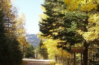
Aspen Campground is an excellent place for campers looking to relax, hike, fish and enjoy the sounds of nature. The campground sits near Jefferson Creek, a few miles downriver of Jefferson Lake. The lake is one of the highest elevation lakes around, capping 10,685 feet elevation and bordered by steep 12,000 foot peaks Fishing in both the creek and lake offer promising catches of trout. Another noteworthy aspect of the campground is its access to the Colorado Trail.
This campground has 9 campsites at an elevation of 9,900 feet with parking spur lengths of 16-30 feet. The campground remains open year-round, weather permitting. Facilities include picnic tables, a vault toilet, and fire rings.
Please note: there is no water available at this campground.
Kelsey is one of two campgrounds within the Buffalo Creek Recreation Area, about an hour’s drive southwest of Denver, Colorado. Visitors enjoy a variety of recreational opportunities, including hiking, rock climbing, mountain biking and trout fishing.
The campground sits at an elevation of 7,400 feet in the Front Range of the Rocky Mountains. Summer temperatures are mild and range from 75-80 during the day to 55-65 at night.
The Kelsey Overlook is just north of the campground along County Road 126, offering beautiful views of the valley below.
Monarch Park is nestled at the base of Monarch Ridge, a short drive north of Monarch Pass. Some campsites at the family-friendly destination are located on the banks of the South Fork Arkansas River, while others lie along a creek. Popular activities in the area include hiking the Colorado Trail and the Continental Divide Trail and fishing. Beaver ponds are near the entrance to the campground and make a great fishing spot for families with young children.
Monarch Pass is a high mountain pass along the southern part of Colorado’s Sawatch Range. The pass crosses the Continental Divide an altitude of 11,312 feet.
The picturesque campground is heavily wooded with ponderosa and Douglas fir. With an elevation of 10,500 feet, visitors are likely to experience chilly nighttime temperatures and cool, mild summer days.
All Payments for Entrance by Cash or Check only
Manitou Lake Picnic Area, is located 7 miles north of Woodland Park, Colorado,. The Manitou Lake Pavilion is located inside the picnic area and is a wonderful group day use picnic area for groups up to 50 people. The scenic spot sits on the west side of Manitou Lake and provides great opportunities for hiking, biking and fishing.
Fishing in the lake is welcomed.
The small Manitou Lake is a 5-acre reservoir fed by Trout Creek. At a 7,700 foot elevation, the terrain is a combination of grassy meadows and ponderosa pines. Visitors can view Mt. Deception across the lake
This is a tent camping facility located on the Colorado Trail. A family fire ring with benches are provided. A vault toilet is also located at the site, but is only open during peak season.
The campground is located on the Colorado Trail (#1776) and is a popular destination for through hikers and backpackers who are hiking the trail from Denver to Durango.
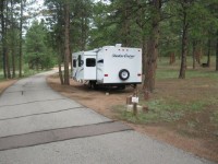
Twin Eagles Campground is 14 miles north of Lake George, off CR 77. It has nine campsites, some of which are walk-in/hike-in, with a maximum trailer length of 22 feet. The elevation is 8,600 feet. This campground is open year round with reduced service in the winter season. Facilities include toilets, tables, and fire rings; there is no water or trash service. There are no reservations at this campground.
This location is available on a first-come, first-served basis only. Visitors are required to physically arrive at the campground to purchase and claim a site. Once on-site, you may be able to pay for your campsite(s) by scanning a QR code using the Recreation.gov mobile app, and the Scan and Pay feature.
Coaldale Campground is located on the banks of Hayden Creek and is a quiet campground with only 10 campsites. Most of the campsites are walk-in sites with small parking areas. Water is available at Hayden Creek Campground. The area is thick with gamble oak, juniper, and cottonwood trees . Sites 1-5 are walk-in sites for tent camping. Vault toilet is available only during peak season
Round Mountain is a small, rustic campground that sits just 6 miles from Lake George and Eleven Mile Canyon, 11 miles from the Florissant Fossil Beds National Monument and 15 miles to Eleven Mile Reservoir. It is also within a short drive to hiking and biking trails, fly fishing, wildlife and bird watching.
Davenport Campground was one of the first Forest Service campgrounds, and is near the now-abandoned Squirrel Creek Campground, the very first Forest Service campground in the country. In 2010, Davenport was rebuilt to evoke the original 1920s design. Adirondack shelters and a common cooking shelter with stone fireplaces were built and old-style log picnic tables add to the historic character of this campground.
The campground offers access to an array of hiking, mountain biking, motorcycle and off-road vehicle trails.
The campground sits in a grassy meadow surrounded by aspen and spruce trees at an elevation of 8,500 feet. Squirrel Creek runs alongside this scenic facility in the Wet Mountains of southern Colorado.
Hidden in the Rampart Range, Flat Rocks is a campground ideal for the ATV and motorcycle riders in the Rampart Range Motorized Trail System. ATVs and off-road motorcycles are allowed within the campground with immediate connecting trail access. Consult the current Motor Vehicle Use Map (MVUM) for specific roads and trails open to off-road vehicles. There is no dump station, electrical, water hook-ups available.
Southside Campground is a small RV facility situated in the Wet Mountains by Lake Isabel. The popular recreation area offers a selection of hiking trails and great fishing and paddle boating on Lake Isabel.
Lake Isabel was built by the Civilian Conservation Corps in the late 1930s, for the purpose of recreation.The 40-acre lake is stocked with trout and the nearby St. Charles Creek offers additional fishing opportunities.
Aspen and ponderosa pine help shade the campground. Lake Isabel impresses visitors with a shoreline that meets the rocky base of the surrounding mountains at an elevation of 8,600 feet.
The Pike and San Isabel National Forest includes over a million acres of wilderness and over half of Colorado’s mountain peaks that reach above 14,000 feet.
Bear Lake Campground is located in the Bear River area, 14 miles southwest of Yampa on Forest Development Road 900.
This campground is on the Flat Tops and is managed by the Yampa Ranger District.
The campground has a rustic nature with most of the 43 sites naturally screened from one another. It also boasts 4 double sites and 1 triple site to accommodate larger groups.
The campground has been a favorite of visitors for many years. It typically opens for Memorial Day and closes sometime in October, dependent on weather and use.
Sites are available on a first come, first served basis. This area accesses some great fishing and hiking.
Surrounded by the 235,000-acre Flat Tops Wilderness, the views are spectacular.
Abe Lee Fishing Site is located on the south shore of Turquoise Lake, six miles west of Leadville. Good fishing plus a plethora of other recreational opportunities are available at this popular lake. Turquoise Lake is stocked with rainbow trout and kokanee. Other species in the lake include brown, cutthroat, and brook trout. Turquoise Lake is rated as fair to good fishing. This is a day use area which closes at 10 p.m. Camping is not allowed.
Weston Pass Campground is adjacent to Buffalo Peaks Wilderness on the east side. It has 14 campsites with a maximum trailer length of 25 feet. The elevation is 10,200 feet. Camping season begins in May and continues to early October with reduced service after Labor Day.
Located on the North shore of Twin Lakes.
Deer Creek Campground is a heavily wooded campground located at 9,168 feet. Mature trees provide shade and hiking trails are nearby. Deer Creek and Camp Creek meet to run next to the campground, providing the soothing sounds of running water. No dump station, electricity or water hook-ups available.
The Indian Creek Equestrian Campground is an ideal camping site for avid horseback riders looking to explore the Indian Creek Equestrian Trail. The area provides a pleasant atmosphere plus nearby access to the Rampart Range, a well known off-highway vehicle riding area.
The area boasts wildlife like mule deer, turkey, elk and black bears. The Roxborough State Park is located to the northeast of the campground as has a reputation for its dramatic red-rock formations.
Campsites sit among a mix of trees that provide both shade and sun throughout the day. These include Ponderosa pine, Gamble oak, Douglas fir, aspen and spruce.
Pike-San Isabel National Forests include over a million acres of wilderness and over half of Colorado’s mountain peaks that reach above 14,000 feet in altitude.
Iron City Campground is located within the Chalk Creek Canyon, which is one of the valley’s most popular areas. This is a small campground with 15 campsites. It is located near the historic townsite of St. Elmo. The historic Iron City cemetery is located on the east end of the campground.
An interpretive sign at the entrance to the cemetery provides information on the early settlers and miners who are buried there.
Camping and campfires are restricted in the Chalk Creek Canyon to developed campgrounds only. Campers who are unable to find a campsite in one of the four developed campground may camp above the townsite of St. Elmo on County Road 267.
Please note, vault toilet is available only during peak season
Horseshoe Campground sits along its namesake creek near a grassy meadow among aspen, Engelmann spruce and Bristlecone pines in the San Isabel National Forest. Trees provide good privacy between campsites, which are located at the base of Sheep Mountain.
Located about six miles down the Halfmoon Road, Emerald Lake is a day use picnic and fishing area in a shady lodgepole pine forest. The lake is stocked with rainbow trout. This site is easily accessible during summer months and inaccessible during winter months. There are 10 picnic sites with tables and pedestal grills. Day use fees for each vehicle is $7.00 payable by cash, check or money order placed inside the self-service fee tube.
Springer Gulch Campground is located in the Eleven Mile Canyon, a short walk from the South Platte River, offering sweeping mountain views at an altitude of 8,300 feet. Fly fishermen will find an abundance of trout and visitors enjoy exploring area trails.
The Timberline Campground, near Kenosha Pass, is about 7 miles southwest of the small town of Grant. The abundance of aspens at the site creates impressive fall scenery along the forested hillside. Wildlife in the area includes golden eagles, elk, mule deer, moose, chipmunks and porcupines.
The family campsites are divided into two loops, that are separated by a rise. Both loops sit among a stand of aspen, spruce and lodgepole pines along Hoosier Creek. The campground sits at an altitude of 9,700 feet and features mild summer temperatures and cool nights.
Baby Doe Campground is situated on the eastern shore of Turquoise Lake in the shade of a lodgepole pine and subalpine fir forest. The family-friendly campground is a popular summer destination for boating, hiking and fishing.
The campground was named after Elizabeth McCourt’s nickname, Baby Doe. She made a name for herself in the Colorado mining community in the 19th century when she took on the rugged work of a miner, and was given her nickname.
Campsites are perched along the scenic lakeshore. The Mount Massive Wilderness Area, a 30,540 acre stretch of primitive land boasting Colorado’s second highest peak at 14,421 feet, is nearby. Much of the wilderness is above timberline with many alpine plant communities and permanent snowfields.
South Meadows campground, located 5 miles north of Woodland Park, provides a scenic spot for campers to rest and enjoy the many recreational offerings of the area. The campground attracts avid hikers and bikers with access to the multipurpose Centennial Trail, as well as visitors looking for a central location for day trips to Pikes Peak and the Garden of the Gods.
Garden of the Gods is a National Natural Landmark in Colorado Springs, featuring incredible rock formations, impressive vistas and a free visitor and nature center.
Campsites are tucked in a stand of ponderosa pines at an elevation of 8,000 feet. To the east is Mount Deception and to the north is the 5-acre Manitou Lake. Afternoon thunderstorms are common in summer months and temperatures are generally mild, with warm and pleasant days and cooler nights.
Hayden Creek Campground is a hidden gem on the Salida Ranger District. The campground is small with only 11 sites. It is located on the banks of Hayden Creek and at the base of the majestic Sangre de Cristo Mountains.
The campground is wooded and very secluded. Sites are best suited to tent camping or small trailers or RV’s. Ideally, vehicles less than 30 ft. work best in the area.
Reservations are not taken for this campground. All sites are first-come, first-served. Also, vault toilet is available only during peak season.
Buffalo Springs Campground sits on a rolling hillside in the San Isabel National Forest, providing an ideal setting for biking, hiking, horseback riding and rock climbing.
Located about 10 miles from the town of Woodland Park, Colorado, Meadow Ridge Campground is pleasantly situated on a ridge above the Rampart Reservoir. Here, campers have access to prime fishing and a selection of mountain biking and hiking trails.
The campground is in the Front Range of the Rocky Mountains, due north of the popular Pikes Peak. The peak has an altitude of 14,110 feet and was first climbed in 1820. Its claim to fame is that it is America’s easternmost peak over 14,000 feet.
Sitting in a ponderosa pine forest at 9,200 feet, the 19-site campground overlooks the Rampart Reservoir. The surrounding terrain includes a mix of grass meadows, spruce, Douglas fir and aspen.
Blue Lake Campground is a developed campground camping and picnicking with the following attractions: Lake and Stream fishing. Blue lake is approximately ½ mile from campground and the tributaries of Cuchara River run through campground.
For trail use, from the campground, take FSR 436 1.5 miles to the non-motorized North Fork Trail #1309. FSR 436 continues to old mine and saddle approximately 500 vertical feet below summit of Trinchera Peak.
Access to the Indian Trial #1300 Trailhead at Bear Lake campground one mile further up FSR 422. This trailhead is a multi user trail system and accesses 23 miles of motorized trails available for ATV, motorcycle, bicycle, foot, and horse use.
Located near the Matchless boat ramp on the eastern shore of Turquoise Lake, Maid of Erin is a beautiful area to enjoy a picnic with friends and family. Facilities include picnic tables, pedestal grills, fire rings, potable water, and vault toilets. You can also access the Turquoise Lake Nature Trail from this site for a leisurely walk around the lake.
Lone Rock Campground, located along the South Platte River, boasts spectacular views and top-notch fly fishing waters. Hikers thoroughly enjoy the nearby Gill Trail and kayakers are drawn to the rapids of the rushing river. Wildlife viewing is rewarding here and campers may spot moose, mule deer, owls, golden eagles and more.
The campground is situated on a hillside rising up from the South Platte River at an elevation of 6,479 feet. Many sites are open and feature a view of the river. Privacy is minimal but ponderosa pines provide some shade. Temperatures are generally mild.
The Crags campground has 17 campsites for tents, small RV’s, or small trailers. It is located in an “out of the way” area and is highly used depending on the time of day and year.
The Crags Trail #664 and the Devil’s Playground Trail #753 start near the campground at the Crags Trailhead located 1/8 mile before the campground.
This is a standard, non-electric campground. It is also a pack it in, pack it out campground.
Devil’s Head Campground resides at the base of Devil’s Head Fire Lookout Tower and Devil’s Head Trail #611. Rock formations dot the landscape and provide outstanding views of the surrounding area. No dump station, electricity or water hook-ups available.
Peak season is 05/22-09/08 and extended season runs through 09/09-09/21. During peak season, the campground offers full service. Extended season has reduced services such as vault toilets, water, trash, or a host may not be available.
This campground appears on the following maps:
- Pike National Forest
- USGS Quad Devil’s Head
- National Geographic Trails Illustrated #135 (Deckers / Rampart Range)
This campground is located 1.7 miles east of Woodland Park on Rampart Range Road, FDR #300. This campground has 13 sites.
This is a standard, non-electric campground. Firewood, shelter, and water are not provided.
19 campsites located in the beautiful Leadville district located right along Turquoise lake. The Mount Massive Wilderness Area, a 30,540 acre stretch of primitive land boasting Colorado’s second highest peak at 14,421 feet, is nearby. Much of the wilderness is above timberline with many alpine plant communities and permanent snowfields. This is a first come first serve campground and sites fill up quickly especially during the weekends.
The Belle of Colorado is a tent-only, non-reservable campground located on the eastern shore of Turquoise Lake in a shaded lodgepole pine forest. Facilities include vault toilets, potable water, picnic tables, fire rings, and pedestal grills. Several desirable campsites are located near the shoreline.
Located on the South Platte River at an elevation of 6,296 feet, Scraggy View Picnic Area is approximately 1 1/2 hours drive southwest of Denver on Jefferson County Road 126. There are five (5) picnic site. No overnight camping available.
Located off the Halfmoon Road (FSR 110), Halfmoon East is a first-come, first-served campground near the Mount Elbert and Mount Massive Trailheads at 9,000 feet. This is a very popular campground for hikers. Facilities include picnic tables, fire rings with grates, and vault toilets. There is no potable water available at this campground, but water can be obtained up the road at Halfmoon West Campground.
High altitude sickness may occur at this altitude.